2023 MED QSR WEB SITE INDEX

Environmental characteristics
37. The presence of numerous islands is another striking characteristic of the Mediterranean. According to some reports there are about ten thousand islands in the Mediterranean, most of them are in the Aegean Sea. The largest islands are Sicily, Sardinia, Corsica, Cyprus, and Crete, and the major island groups include the Balearics off the coast of Spain and the Ionian, Cyclades, and Dodecanese islands off Greece.
Sea water masses and circulation:
38. The average annual sea surface temperature in the Mediterranean show strong gradients from west to east and from north to south, as well as a strong seasonal variation between 10 and 28°C, reaching 30°C in summer. This sea is considered a warm temperate sea. It is characterized by high salinities, temperatures and densities.
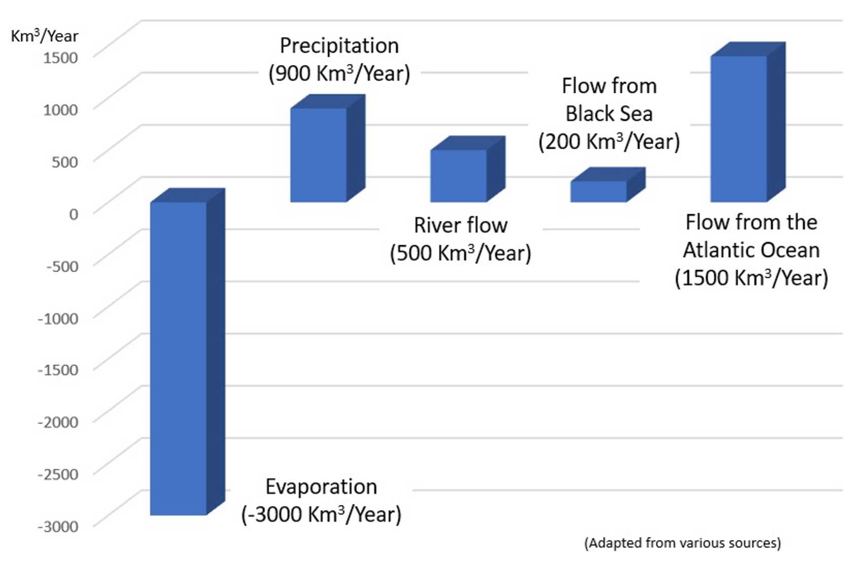
Its deep waters have a constant temperature around 13°C with an average salinity of 38‰. The Mediterranean water column is made of a surface layer, an intermediate layer and a deep layer that sinks to the bottom. The evaporation water losses are partially compensated by the rivers that flow into the Mediterranean and a surface current from the Black Sea through the Bosporus, the Sea of Marmara, and the Dardanelles. The main compensation of evaporation losses is provided by a continuous inflow of surface water from the Atlantic Ocean through the Strait of Gibraltar. The current it generates is the main driver of the water circulation in the Mediterranean. It flows eastward along the southern coasts of the western basin, then across the Sicily Strait and continues along the southern coasts of the eastern basin.
Figure 2: Annual hydrological balance
of the Mediterranean Sea
39. With a low amplitude of semi-diurnal tides (30-40 cm), except for the northern Adriatic and the Gulf of Gabes where it can reach up to 150 and 180 cm, respectively, the Mediterranean Sea is considered a medium microtidal sea by global ocean standards.
Trophic level:
40. In terms of nutrients, the Mediterranean is among the most oligotrophic oceanic systems. The most eutrophic waters are located on the north shore in the western basin and Adriatic at the mouth of the large rivers Rhone, Ebro and Po. However, riverine nutrient inputs are relatively low, as most river systems discharging in the Mediterranean Sea are small. The main source of nutrients in the Mediterranean lies in the inflowing Atlantic surface waters at the level of the Gibraltar Strait. As the waters move eastwards from the Gibraltar Strait, they become depleted in nutrients. By the time they reach the Egyptian coasts, their nutrient signature has almost disappeared. Additionally, the Nile River nutrient signature has disappeared due to the 1960s Nile Dam construction. All this contributes towards making the Levantine Basin (at the eastern part of the Mediterranean Sea) one of the most oligotrophic areas in the world ocean. The outflow of Black Sea surface waters constitutes another source of nutrients to the Mediterranean, but its influence is limited to the north Aegean zone.
Biodiversity:
41. Home to 17,000 species of fauna and flora representing respectively 7.5% and 18% of the world’s marine flora and fauna, the Mediterranean Sea is a hotspot of biodiversity. The evolution of the Mediterranean marine fauna and flora over millions of years in a unique mixture of temperate and subtropical species gives this almost closed sea the second place in the world in terms of endemic species richness with more than a quarter of its species found nowhere else on Earth.
42. The species diversity of the Mediterranean, although unevenly distributed between the eastern and western basins, is higher than in most other regions of the world, due to the geological history of this sea, its close communication with the Atlantic and its position at the junction of three continents Europe, Asia and Africa which make it a melting pot of biodiversity.
43. The uniqueness of the Mediterranean biotope comes from a combination of morphological, chemical and biotic characteristics reflected by the presence of certain ecosystem building species and assemblages. The meadows formed by Posidonia oceanica and the bioconcretions of the coralligenous assemblages are among the most important marine ecosystems of the Mediterranean Sea. They provide a wide range of ecosystem services and sustain many human activities such as fisheries and tourism. They are, however, particularly sensitive and vulnerable to coastal urbanization, pollution, turbidity, anchorages, trawling, etc.
44. The shallow coastal waters are home to key species and sensitive ecosystems such as seagrass beds and coralligenous assemblages, whilst the deep waters host a unique and fragile fauna. Many of these species are rare and/or threatened and are globally or regionally classified by IUCN as “endangered” or “critically endangered”, such as the monk seal Monachus monachus, the Mediterranean shellfish Pinna nobilis and cartilaginous fish species (sharks and rays). Many other species have strongly regressed during the 20th century.
45. Non-indigenous and invasive species (NIS) are increasingly present in the Mediterranean Sea. As of 2020, more than 1,199 non-indigenous species have been reported in the Mediterranean Sea, 513 of which are considered as established. The highest number of established alien species has been reported in the eastern Mediterranean, whereas the lowest number was recorded in the Adriatic Sea. Of those established species, 107 have been flagged as invasive.
46. The NIS in the Mediterranean Sea are linked to four main pathways of introduction: the corridors, shipping (ballast waters and hull fouling), aquaculture, and aquarium trade. Corridors are the most important pathway of introduction (33.7%) followed by shipping (29%) and aquaculture (7.1%).
47. The vast majority of the marine NIS recorded in the Mediterranean have their native distribution in the Western and Central Indo-Pacific and Red Sea, being mostly associated with introductions into the Mediterranean Sea through corridors.
48. In 2021, the number of Marine and Coastal Protected Areas (MCPAs) recorded in the MAPAMED (https://mapamed.org/) database reached 1,126 sites covering 209,303 km², including only 0.06% of strictly protected areas. There are no other effective area-based conservation measures (OECMs) reported for the Mediterranean to date; however, combining areas that could be potential OECMs (i.e., 1 Particularly Sensitive Sea Area and 8 Fisheries Restricted Areas) the total MCPA and potential OECM coverage currently stands at 9.3% of the Mediterranean Sea. As shown in https://mapamed.org/, there is a large disparity in MCPA coverage between countries, with the majority of MCPAs occurring in the western Mediterranean Sea and 90.05% occurring in in the northern part of the Mediterranean. In addition to geographical representation, there is also uneven distribution of MPAs according to sea depth, with less than 4% of depths greater than 1,000 m covered by MPAs. As the region now faces new targets, not only is coverage expected to increase, but it is essential that coverage is more equitably represented across Contracting Parties and the different ecosystems.
Climate change:
49. The Mediterranean region climate is characterized by mild winters and hot and dry summers. From the West, the Atlantic Ocean regimes have a great intra-seasonal and interannual variability influences in the Mediterranean reaching mainly the northeast part of the Mediterranean land and sea, whilst the Eastern and Southern climatic regimes provide the characteristics of the southern Mediterranean areas.
50. Climate change is one of the most critical challenges that the Mediterranean region is facing. In its Sixth Assessment Report the IPCC concluded that “during the 21st century, climate change is projected to intensify throughout the region. Air and sea temperature and their extremes (notably heat waves) are likely to continue to increase more than the global average (high confidence)”. The report predicted (i) a decrease in precipitation in most areas by 4–22%, depending on the emission scenario, (ii) a further rise in the Mediterranean Sea level during the coming decades and centuries, likely reaching 0.15 to 0.6 m in 2050 and 0.6 to 1.1 m in 2100 (relative to 1995–2014) and the process is irreversible at the scale of centuries to millennia; (iii) coastal flood risks will increase in low-lying areas along 37% of the Mediterranean coastline with an increase in the number of people exposed to sea level rise, especially in the southern and eastern Mediterranean region, and may reach up to 130% compared to present in 2100; (iv) ocean warming and acidification will impact marine ecosystems, with however uncertain consequences on fisheries.
51. For the marine environment, the available data indicates that since the 1980’s, documented impacts on marine Mediterranean species and habitats were attributed to climate change. These included frequent and drastic mortalities of sessile benthic species of the infralittoral and circalittoral communities. For the deeper Mediterranean ecosystems, recent scientific articles reported that in the 1990’s, Climate change caused an accumulation of organic matter on the deep-sea floor and altered the carbon and nitrogen cycles.
52. By affecting all trophic levels, the Climate Change may alter the distribution of some species as a response to changes in the availability of their preys. Indications were reported about shifts in the distribution and density of cetacean species in relation to variations of sea surface temperature (SST). Furthermore, the rise in seawater temperature has the potential to favour pathogen development and transmission. It is also an accelerating factor for the introduction and spread of non-indigenous species. The thermal stress it generates on the native species make them weaker competitors which favours the establishment and growth of non-indigenous species populations in their habitats.
53. The consequences of climate change in the Mediterranean are especially manifested through hydrographic alterations of the Mediterranean Sea, which is explained in detail in the last Copernicus Ocean State Report – 6th issue (2022) and the MedECC 2020 First Mediterranean Assessment Report (MAR1, MedECC 2020).
54. Taking advantage of the freely available high-resolution satellite-derived sea surface temperature dataset from the Copernicus Marine Environment Monitoring Service, that covers the longest period, it could be observed that the surface temperatures in the Western Mediterranean Sea have been rising over the last 39 years with an average rate of 0.036°C yr-1 (Pisano et al. 2020; Krauzig et al. 2022).
55. Over the last three decades, marine heatwaves (MHWs) in the Mediterranean Sea have caused mass-mortality events in various marine species, and critical losses for seafood industries. Three different sea surface temperature products (Copernicus Marine datasets) show that the maximum intensity, frequency and duration of MHWs have all increased on average over the Mediterranean Sea since 1993.
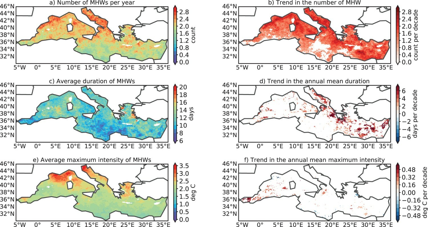
56. Based on the satellite observations over the 1993–2019 period, the number of MHWs showed an inhomogeneous spatial distribution in the entire Mediterranean Sea, with a lower number of events per year in the south-eastern Mediterranean Sea and slightly more events in the western Mediterranean Sea, especially in the north-western area, as well as the Adriatic Sea (Dayan et al. 2022). On average, the number of MHWs substantially increased across the entire Mediterranean Sea by approximately 1 event per decade. The number of MHWs increased significantly in distinct ways in the four sub-regions (Figure 3). Satellite observations show that the number of MHWs has increased the most in the Adriatic Sea (1.61 ± 0.17 per decade), followed by the Aegean Sea (1.30 ± 0.23 per decade), the western Mediterranean Sea (1.13 ± 0.12 per decade) and finally the eastern Mediterranean Sea (1.01 ± 0.14 per decade). Satellite observations reveal that the duration of moderate and strong MHWs increased the most in the Adriatic Sea (23.01 days ± 2.67 and 3.22 ± 0.53 days per decade, respectively), while the duration of severe and extreme MHWs increased the most in the Aegean Sea (0.59 ± 0.18 days per decade) and the western Mediterranean Sea (0.53 ± 0.15 days per decade).
Figure 3: Spatial distribution of the marine heatwave (MHW) metrics from satellite-derived SST record over the period 1993–2019
Source: Dayan et al. 2022
57. In the future, MHWs may undermine many benefits and services that Mediterranean ecosystems normally provide, such as food, maintenance of biodiversity, and regulation of air quality (Dayan et al. 2022, Martín-López et al. 2016). MHWs are predicted to become more intense and more frequent under anthropogenic warming, embodying a growing threat to both marine ecosystems and human society (Dayan et al. 2022).
58. The annual 99th percentile of significant wave height (SWH) – a measure of extremes – has increased almost everywhere in the basin during the last 28 years at a maximum rate of 0.026 m yr-1. The most significant upward trends were found in the south-eastern Levantine and eastern Alboran Seas (Figure 4: Long-term 99th percentile of SWH in meters (1993–2020)), followed by the Adriatic Sea and contained areas of the Tyrrhenian (Zacharioudaki et al. 2022).
Figure 4: Long-term 99th percentile of SWH in meters (1993–2020). Source: Zacharioudaki et al. 2022
59. The water mass temperature and salinity changes of the water outflowing from the Mediterranean Sea through the Strait of Gibraltar are 0.077°C decade-1 and 0.063 Practical Salinity Scale (PSS)decade-1, respectively, compared to 2004 (MedECC 2020).
60. Mediterranean Sea water surface pH has decreased by -0.08 units since the beginning of the 19th century, similar to the global ocean, with deep waters exhibiting a larger anthropogenic change in pH than the typical global ocean deep waters because ventilation is faster (MedECC 2020).
Nutrient enrichment causes eutrophication and may provoke harmful and toxic algal blooms, trends which will likely increase. Harmful algal blooms may cause negative impacts on ecosystems (red-tide, mucilage production, anoxia) and may present serious economic threats for fisheries, aquaculture and tourism (MedECC 2020).
61. As a result of increasingly pronounced hydrographic alterations, the marine habitats in the Mediterranean Sea are increasingly endangered, and some of them are threatened with complete extinction. It stands out in particular for the Adriatic Sea where current climatological and oceanographic research (Vilibic et al. 2013; Pastor et al. 2018; Vilibic et al. 2019; Mihanovic et al. 2021; Sepic et al. 2021; Bonacci and Vrsalovic 2022; Vilibic et al. 2022) indicates that the Adriatic Sea is already experiencing significant changes in hydrographic alterations, and their intensity will become more and more pronounced, while the occurrence of climatological extremes could increase.
1. The Mediterranean Sea
Environmental Characteristics
Socioeconomic characteristics
Regional
Cooperation


